

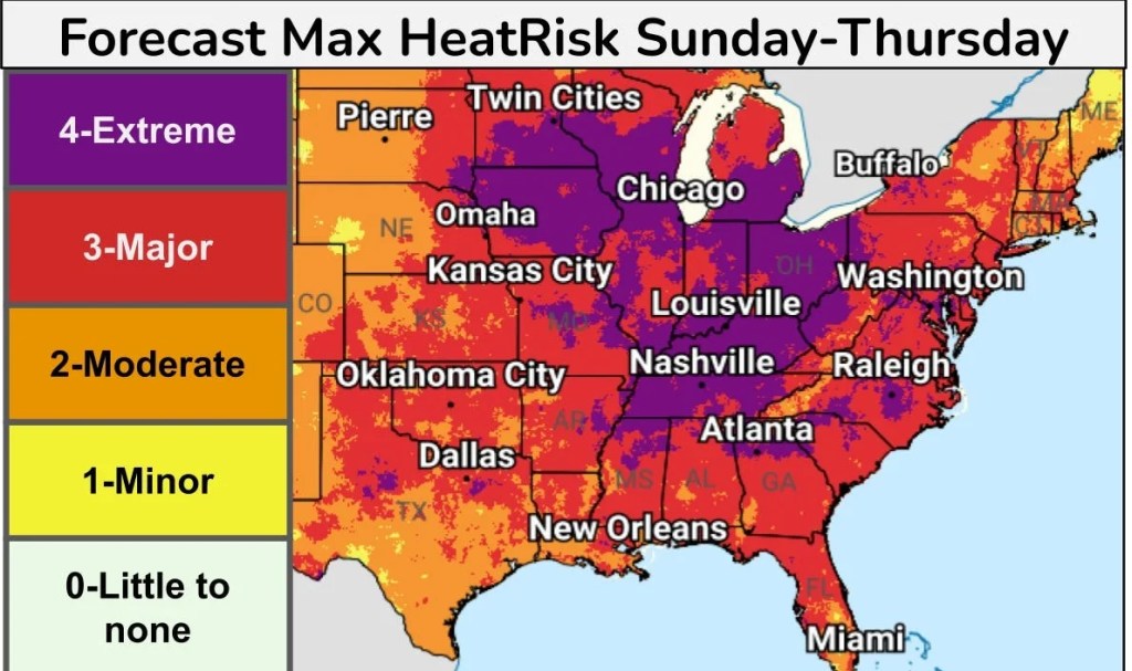
Those who live anywhere east of the Rocky Mountains might want to start planning now to stay safe and cool through the July 4 weekend, as the National Weather Service warns days of “significant, dangerous heat” could be ahead.
And they’re not talking normal summer heat. This is triple-digit heat indices and blazing hot temperatures that could break records and linger through Independence Day and beyond.
Temperatures are going to be “well above normal across much of the Central and Eastern U.S.,” said Frank Pereira, a meteorologist at the Weather Prediction Center, part of the National Weather Service.
From July 3-9, weather service forecasters are seeing increasing confidence for well above-normal and possibly record-breaking summertime temperatures and elevated extreme heat risks for many areas in the Midwest and Eastern U.S. The developing pattern could be favorable for another Omega block-like pattern bringing impacts that last further into July, the forecast discussion noted.
Though uncertainty remains around the details, the enduring heat wave is expected to begin taking hold over the June 27-28 weekend, then expand and endure through at least July 4.
The Rockies and the Northwest, however, are going to see “quite a strong contrast” that includes well below-normal temperatures and possibly some high-elevation snow in the Northern Rockies.
East of the Rockies “things are going to be quite toasty and well above normal through next week, and really starting to ramp up in the Eastern U.S. as we get into the middle of next week,” Pereira told USA TODAY on June 26.
On June 30 and July 1, “we’ll start to see records fall from the Ohio Valley into the mid-Atlantic and Northeast,” he said. “By Thursday, (July 2), we’ll be looking at temperatures in the triple digits from the Carolinas northward up through the mid-Atlantic, including D.C.”
From the Dakotas and eastward, expect temperatures in the upper 90s with humidity that will make it seem closer to 110 degrees, he said.
Dangerous overnight lows
Compounding the whole heat issue, “it’s really not going to cool off much at night,” Pereira said. “We’re looking at perhaps even more widespread overnight warm low temperature records.” In locations where the overnight lows remain in the low 80s, it will really limit overnight relief.
A forecast discussion from the Raleigh National Weather Service office on June 26 warned: “Begin preparations now for the potential for highs possibly 100+ for 3-4 consecutive days.” Feels-like temperatures outside the Triad could reach as high as 112, the forecast stated. “To make matters worse, overnight lows may have a hard time dropping below 80, with 90 still possible at night.”
When overnight lows remain so warm, it makes it harder for streets, lawns and buildings to cool off, and increases the dangers for heat-related illnesses, especially for the elderly and those who may not have adequate cooling systems.
Read More Here: https://www.yahoo.com/news/weather-news/articles/blockbuster-heat-wave-forecast-isnt-100441476.html


Leave a Reply