

With Hurricane Hilary fast bearing down on the region and rain already beginning to fall in Southern California’s desert areas, officials on Saturday are urging residents and visitors on Catalina Island and those living in portions of San Bernardino County to evacuate.
Gov. Gavin Newsom Saturday declared a state of emergency for the region and that thousands of first responders were in place as the storm moved in.
“We’re mobilizing all of government as we prepare and respond to this unprecedented storm,” Newsom said in a statement.
National Weather Service forecasters’ warning of lashing winds, intense rain and harrowing conditions along the beaches prompted Los Angeles County officials to advise people on Catalina Island, particularly those with medical conditions or those who might be in need of help during a natural disaster, to evacuate on the Catalina Express. The county noted there could be prolonged utility outages on the island.
Flood concerns also prompted San Bernardino County sheriff’s officials to issue an evacuation warning for the Oak Glen, Forest Falls, Mountain Home Village, Angelus Oaks and Northeast Yucaipa regions Saturday morning. Orange County issued a voluntary evacuation alert in the Bond fire burn area.
The storm has prompted officials to cancel events and issue dire alerts, particularly as the system moves across southwestern California on Sunday and Monday. The National Weather Service issued a tropical storm warning at 8 p.m. Friday for the area from the California-Mexico border to Point Mugu and for Catalina Island.
“This is actually the first time that tropical storm watches have been issued on the West Coast of the United States,” said Elizabeth Adams, a meteorologist for the National Weather Service in San Diego. Typically, when a tropical storm makes its way to the southwestern U.S., it has severely dissipated, weakening to a depression or storm remnants, she said. The only tropical cyclone to actually make landfall in Southern California was in 1939.
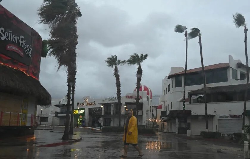
Hilary, currently a Category 2 hurricane, had sped up and shifted slightly eastward in its track. It was a Category 4 on Friday and weakened to a Category 3 Saturday morning. Still, officials said flooding remains a major risk, with special concern around inland deserts and mountains.
This means the most severe impact of the storms will likely be felt late Saturday and Sunday across Southern California.
“The system has gained some speed, and it’s going to be moving through a little bit on the quicker side. By the time we get to Monday afternoon or so we’re expecting most of the precipitation to have moved out of the area aside from a few lingering showers,” said Ariel Cohen, the meteorologist in charge at the National Weather Service in Oxnard.
This could cut down on rainfall totals in some areas, Cohen said, “but there’s so much moisture pushing into the area that we’re still looking at the potential for flooding.”
Across Southern California on Saturday, residents rushed to stock up on household essentials like water— leaving aisles in grocery stores bare — and sandbags to protect their homes from flooding.
“Please prepare, please take this seriously,” said Los Angeles Mayor Karen Bass. “We are not used to hurricane preparation, but it’s another example of climate change. So we have to be prepared for climate events that we are not used to. Stay safe.”
As the system moves through, parts of Los Angeles County could see half an inch to three quarters of an inch of rain per hour. Forecasters are also predicting heavy rain in Orange County, up to 3 inches in some areas. But the mountains and deserts are widely expected to be the most impacted, with more than 5 inches of rainfall possible. Early Saturday rain was already starting to fall in San Diego’s desert areas.
“They could see quite catastrophic amounts of rain,” said Casey Oswant, a meteorologist for the National Weather Service in San Diego.
Hilary, which was about 235 miles west-southwest of the southern tip of Mexico’s Baja California Peninsula as of 8 a.m. Saturday, is expected to remain at hurricane strength as it approaches the coastline. Authorities there are bracing for damage.
Hilary is expected to weaken to become a tropical storm before reaching Southern California. The center of the storm could arrive in the region by Sunday night, but its wide-reaching effects will be felt in the area much earlier in the weekend and continue through Monday.
“It’s so strong right now, and it is going to … make a beeline for Southern California,” said Daniel Swain, a UCLA climate scientist. “It simply isn’t going to have time to fall apart nearly as much as these systems usually do before they reach California.
A tropical storm watch is also in effect for almost all of southwestern California, from the Mexico border to Point Mugu, including eastern deserts and Catalina Island, which the National Hurricane Center said is a first for this area. The watch indicates that tropical storm conditions are possible — meaning more than 39 mph sustained winds — within 48 hours, according to the hurricane center.
Forecasters expect sustained winds whipping through the area at 35 to 45 mph. The highest gusts — up to 50 or 60 mph — are expected in the mountains and deserts. Officials warn residents to stay away from tall objects, such as trees or power lines, which could get knocked down during severe winds, and to secure outdoor furniture.
When the eye of the storm arrives Sunday, San Diego and Orange counties can expect 40 to 60 mph winds, the National Weather Service said. Gusts in excess of 80 mph could hit places such as Joshua Tree National Park.
Those winds also could spur tornadoes — which could be particularly hard to see as they would be embedded with rain — with probable threats Saturday night through Sunday, Adams said.
“The biggest time and place that we see that tornado threat is associated with rain bands out ahead of the system,” Adams said. She said tornadoes spawned by tropical storms often strike very quickly but are usually short-lived.


Leave a comment